


he Our Lady of Miracles feasts that take place here in mid-August are responsible for the largest pilgrimages that the island knows, a means the believers use as a way of returning the “graces” obtained.
Head to the Casa do Espírito Santo and walk a few yards until the last houses of the Lajedo are left behind and you reach a viewpoint, the spot where the nature trail actually starts. On your way there, some Azorina vidalii in the slope pose for the picture.
The well-maintained and landscaped viewpoint, located next to an old barn, allows you to distinguish the huge Cartário islet in the landscape, and, to the right, next to the sea, a bare rocky flagstone-like platform, which is in the origin of the name given to the parish — and was also used to make the landing easier at the Portinho do Lajedo, a tiny inlet contiguous to the platform. In this area, known as Baixa Rasa, the liner Slavonia, which had sailed from the United States towards Italy, ran aground on the 10th of June 1909, at dawn. Since it was only 25 metres away from the shore, all 597 people on board were evacuated and continued their journey on other boats. Also, many of the people’s belongings were taken from the liner, and, in the months that followed, a great deal of the remaining belongings was brought to land, along with parts of the boat. Now you have 3 kilometres and 3 long wide valleys overlooking the ocean and dotted with hard basalt outcrops ahead of you before reaching the parish of Mosteiros. Continue down the dirt road, and, when you reach the first fork, go left into a partially cobbled footpath. Ahead of you is the Pico da Terra Nova, with a rivulet at the bottom, which you will have to cross. After going around this peak, you will reach the stream of Lapa valley, and, soon after, you will find yourself walking on a stone bridge that crosses the river’s main affluent. Go around another elevation, and once you reach the third valley — Ribeira do Fundão — you will be able to see a number of islets. You have just entered the Protected Area for the Management of Habitats or Species from the South and Southwest Coast.
At the top of the valley, considerably large basaltic veins, like stone sentinels, emerge from the green of the pastures. Choose wisely the stones you will be stepping on to cross the stream of Fundão. A steep slope will allow you to avoid 130 metres of uneven land, after which you will reach the asphalt road of Mosteiros. However, during this ascent, you will enjoy the best views of the imposing Rocha dos Bordões.
As for the origin of the name of this parish — Mosteiro, to the centre of which you are about to arrive — some say it is due to the numerous islets along the shore, while others say it had to do with the large rocky peaks away from the shore. The most distinctive peculiarity of the traditional architecture of Mosteiro is maintained in the approximately 20 stone arches that can still be seen in the ground floor doors (lojas) of some houses. Those arched doors were the entrance to the space where the farm implements and the oxcarts were kept. The need for a wider opening dictated the use of the stone arch, more stable and easier to build than the typical stone lintel placed at the top of the windows and remaining narrower doors of the house. According to the most recent census, which date back to 2011, the five least populated parishes in the whole country are all located in the Flores island, and, among those, the one that has fewer permanent residents is that of Mosteiros, with only 43 inhabitants. So, do not be surprised if you don’t see anyone to whom you can hello or ask for information.
Go down until you reach the Chuch of Santíssima Trindade, where a feast takes place on the third weekend of August. There you can refresh yourself in the fountain located in front of the building. Keep going down the Cabo de Baixo das Casas street until it curves to the right. Once you have reached that point, leave the asphalt and cover the concrete, passing by a well-preserved house with some Azorina vidalii — one of the most beautiful plants from the Azorean endemic flora — growing out of the holes in its walls. After crossing the bridge over the stream of Mosteiro, a stream where trout grow, you will find some barns harmoniously fit into the landscape, providing you with the opportunity to take some beautiful pictures of this rural scenery. Here you can also find butter factories that used to operate in the past.
Go up, heading towards the road, and walk 800 metres more. You will soon be able to see the Caldeira, a depression of fertile soil and running water that enabled the establishment of a small number of old settlers. Now completely deserted, there remain only a few houses that have not collapsed and serve the purpose of storing farming tools. Leave the asphalt road and make a turn to the left, entering an old footpath that passes next to the ruins of other houses swollen by the vegetation.
After leaving the road, walk 200 metres, leaving the Caldeira behind, and make another turn to the left, entering a trail next to a water reservoir — a trail that goes around a hill along the side facing the ocean. That hill is called Cruzeiro da Fajãzinha, and is one of the best viewpoints in this parish.
This shortcut will take you to the Ladeira do Portal: the oldest descent in the escarpment that for centuries was the only passable way that connected Fajãzinha to the rest of the island. It is usually more than 2 metres wide, and parts of it still have the original cobbles used to pave the path.
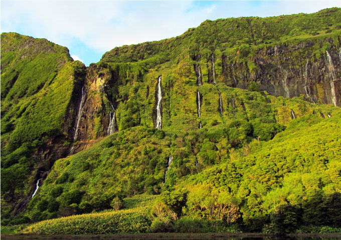
Here you wil have the first glimpses of the Fajãzinha valley, seen from above: a breath-taking and spectacular landscape, where the inland cliffs and several waterfalls grab our attention, as well as the Ribeira Grande river mouth, the largest and most dangerous in the whole island, transformed into a pebble beach, and, in the distance, Fajã Grande. Fajãzinha and Fajã Grande were, until a few decades ago, one of the most important fruit production areas in the island.
To enter Fajãzinha you have to pass next to the Church of Matriz de Nª. Sr.ª dos Remédios, whose churchyard, curiously enough, is paved with pebbles. The interior is quite rich in terms of contents and decoration. Visit it and enjoy the painting in the ceiling and the altars, the brownish wooden pulpit with fine golden elements, the columns painted so as to resemble marble, and even more details. The feast in homage to the patron saint takes place in the last Sunday of the month of August, but in the beginning of the summer you also have the popular Festas do Espírito Santo (Feasts of the Holy Spirit).
You reach the Largo do Rossio. With a population of only 76 inhabitants (the second smallest in the country), there are, nonetheless, some shops where you can buy something you might need, and there is even a very famous typical restaurant. Many of the houses in Fajãzinha have unusually wide façades, with one door and several windows. Sometimes, two semi-detached houses accentuate even more this feature.
Go around the café following to the right, then turn left behind it: you will reach the Largo do Outeiro, next to a small chapel rebuilt in 1974. Go down to the right and, next to the drinking through, then cover the Engenho street. It leads to a path that goes down to the traditional cheese dairy, but you must go up, turning to the Espinhaço street. Ahead, after you cover it, keep going up the trail to your right.
In the past, there were four ways of getting in and out of Fajãzinha: head south by going up the Ladeira do Portal (which you covered to go down); head north towards the Aldeia da Cuada, crossing the small river and covering narrow paths; head west towards the waterfalls, going up the Caminho da Cruzinha, now under the asphalt of the current main access to the parish; or, just as you are doing, go up using the Caminho das Cabeçadas and the Caminho da Ribeira da Alagoa, with its cobbled stairs.
This is an area full of citrus trees, apple guavas, banana trees, some vineyards and chestnut trees, but also yam, and, of course, some portions of land with grass or corn. There are many taps here, some of which with hoses to fill the tanks for the livestock. Close to the end of this ascent, you will find a door that opens to a block of flats in ruins whose construction dates back to 1951. You begin listening more distinctly the water from the Ribeira Grande making the rocks roll. In a recent episode, the stream of this small river, that runs abundantly all year, was so strong that it destroyed everything in its way, creating an insurmountable ravine that isolated Fajã Grande and its inhabitants.
When you leave the road, you see the water mill that used to grind corn and rye. Even though it is private, it is still operational thanks to an initiative by the Lajes town council, which hired Mrs Maria de Fátima to show and explain the visitors how the wheel mill works. Here, each component has its name and each tool has its utility.
Take the path towards Fajã Grande, crossing the Ribeira Grande bridge. You will find a sign indicating Poço da Alagoinha. Make that 800 metres detour so you can enjoy a surprising landscape. In order to do so, you have to go up the old footpath that enabled the Fajãzinha inhabitants the access to this place, always under a vegetation covering. That freshness is even more intensely felt when you see the water that runs in a stream at the final stretch of this ascent. You have finally reached the lagoon, a magnificent landscape where more than a dozen small cascades drop their incessant water from the top of an imposing and verdant rock into a still water lagoon. Take in the scenery calmly, slowly, resting your legs and your mind.
However, it is imperative to clarify that this place is incorrectly called Poço da Alagoinha. Fajãzinha inhabitants tell me that the Poço da Alagoinha actually exists, but is located approximately one kilometre south, where other cascades from the same rock converge in another area and provide water for the water mill you saw before. This lagoon you are now visiting is given the name Poço Ribeira do Ferreiro by the locals, and, about 40 years ago, it still dried every summer, growing grass that was reaped do feed the livestock. The steep footpath made that activity possible, and also allowed the inhabitants to collect wood for the ovens and have access to the places where yams were cultivated. Since then, a change in the hydrological system made possible the continuous water flow in this lagoon throughout the whole year.
Return to the road, cross the Ribeira do Ferreiro bridge, and turn right immediately after, entering a 660 metres long asphalt path at the end of which, next to an agricultural building, you will find one of the old trails that the population of Fajã Grande covered to have access to these higher lands, closer to the interior, and use them to their benefit. Today, some of them are still farmed, while others show signs of abandonment. This cobbled trail winds up and down, and is sometimes slippery in certain points. On both sides grow some rare species, such as the endemic plant Chaerophyllum azoricum. You will pass near an asphalt road, or even cross it, but do not deviate from this historical trail, keep walking straight forward and you will soon see the first houses in Fajã Grande.
You will finally enter the Padre José Luís de Fraga street. Turn left and walk towards the centre of the village. Past a few houses and fountains, you will reach the Pe. José António Camões garden and the main cobbled artery that crosses an old part of Fajã Grande’s dwellings, a street called Senador André de Freitas, a charitable politician who was born here in 1860.
Pass by the Argonauta, a resort that offers accommodation and other services. Past and above the church you will find a convenience store (a small market and a bar), a compulsory stopping point for foreign tourists in the summer, who enter the place to drink something refreshing or taste their mistura (mixture), a sweetened alcoholic beverage prepared by the owner. The neighbouring single-nave Church of São José with a little unusual painting on the main door is the place where the Feast de Nª. Sra. da Saúde takes place on the 2nd Sunday of September.
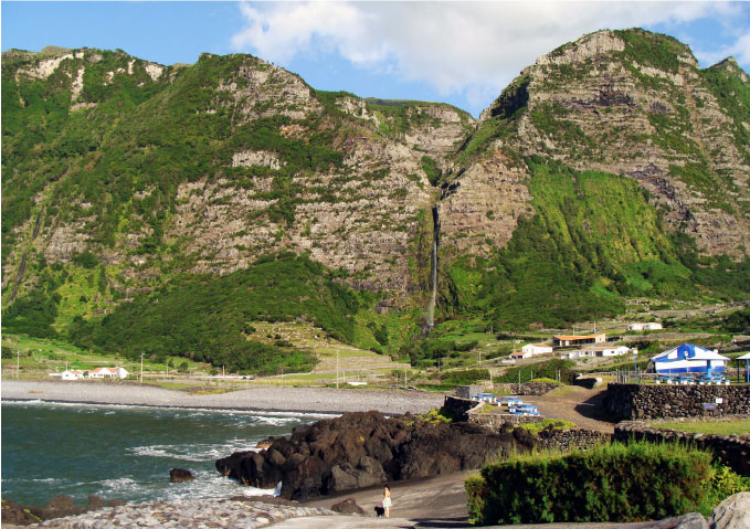
The path leads us to the port, perhaps the only one in the island’s west coast, now used mostly by pleasure boats. This nature trail ends a few metres away from the crossroads where, if you turn right, the road will lead you to the Ponta da Fajã. However, keep going straight forward, past an area with grills where people eat, until you reach the bathing area. About 20 years ago, works were initiated next to this port so as to create a bathing area that offers a café with outdoor seating and a restaurant that, after adopting several other names, is now called Papadiamandis, the name of a Liberian cargo ship that sank on the 22nd of December 1965, at dawn, only 300 metres away from here. Just one of the many dozens of shipwrecks that took place near the Flores Island. This pleasant bathing area is decisive to explain why Fajã Grande has become one of the most sought places in this municipality during the summer. During the rest of the year, it is still a fascinating place, uniquely located between the sea and the mountain. Take the opportunity to see the Poço do Bacalhau or relax while enjoying the magnificent sunset this place has to offer.


