


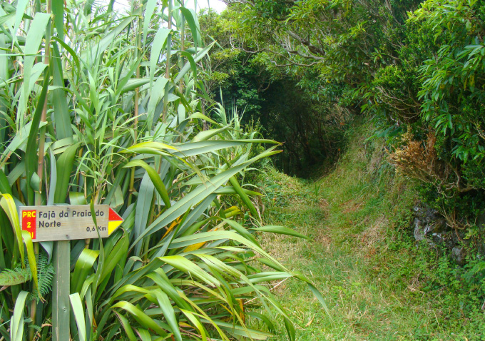
Go down between the agricultural fields that are apparently not to well suited to this activity. Around here mostly corn is grown, mixed with a lot of cane. A typical sight in Faial island where, due the shortage of stone to build walls, we usually see cane and hydrangeas separating agricultural plots.
Up ahead you reach a crossing of two roads: one that will take you to the path that goes down to the headland, and another that will bring you back through another path. We pass some greenish water tanks without hearing the usual frogs... You only hear the machines in the stone quarry located in the headland. We arrive at a small rectangular pasture, sided by Phormium tenax and Buxus sempervirens, that gives entrance to an ancient footpath, carved in rock by the needs of men, that gives access to the headland.
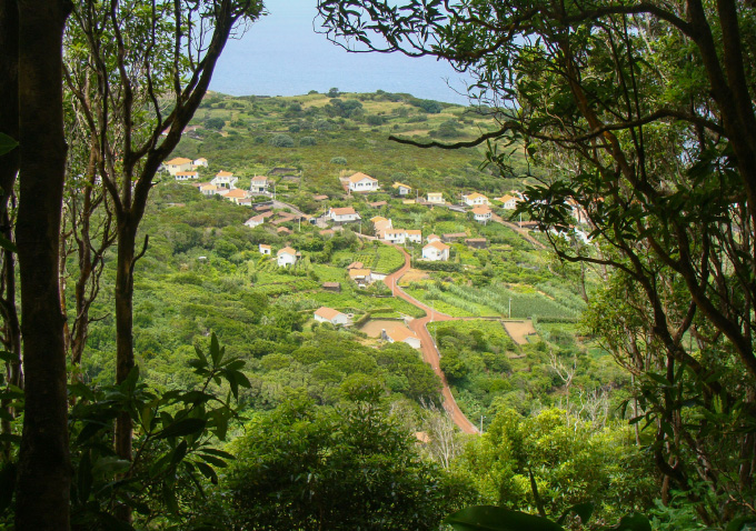
We start to have the first glimpses over the houses and lands down below. The kite birds fly over this area. The tufts of Carex hochstetteriana, the Polypodium azoricum, the Hedera azorica, the Smilax divaricata, the Lysimachia azorica and the Picconia azorica, all of them endemic, are, along with the Asplenium hemionitis (a star shaped leaf fern), the most interesting notes in the existing flora.
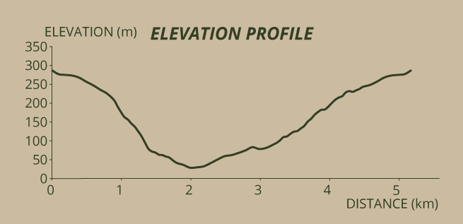
It is really a very pleasant descent, with the sun piercing through the canopy of a wood with diversified trees: Cryptomeria japonica, populus sp., Pittosporum undulatum, Morella faya. Sometimes on a gentle slope, others over stone steps, the winding downward path becomes easy and safe. In each sharp turn of the way, it is possible to take panoramic pictures of the houses of the headland and of the coastal lavas, sometimes there are little detours to do so.
Closer to the end, you will pass by a 1937 fountain, dedicated to Nossa Senhora da Rocha and you start to see the semi-savage vine climbing over the trees, holding on to the branches with its tendrils, so not to drop the bunches of grapes.
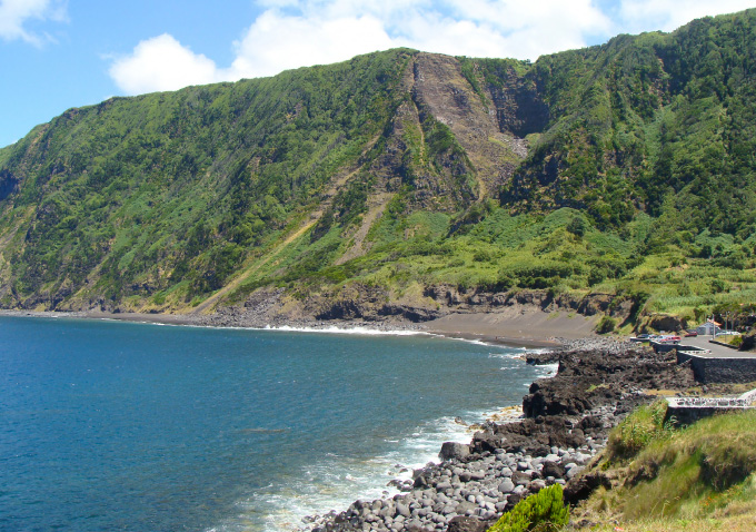
We finish the descent next to the stream of Serrado Novo. The path now continues going down the Rua das Adegas (Wine-cellar’s Street). In the headland, some of the wine-cellars are well restored, transformed in to summer houses, or permanent ones of some of the inhabitants of Faial. Other wine-cellars keep their original function, because this is still a wine producing area. Finally, you can admire the Rocha da Fajã, through which you came down, that shows, on top, the little valley from where the Cabras’ stream hurls down.
You start to hear the sea rolling the pebbles and you reach the car parking that gives access to Fajã beach sand strip, a bathing area without surveillance as the signs show, but very sought after, including for surfing. It possesses public rest-room facilities.
Walking a little further on the coastal road you pass the simple Fajã Park, where you can picnic in the shadow cast by a Salix or drink water from the small fountain there. Continuing further you will find a “tidal well” built in 1768 and belonging to the “Cerca”. It was covered with a mesh after the 1998 earthquake that may have moved some stones, thus creating some danger.
The trail continues turning then and there to the left through an old path, but in case you want to, you can walk 150 metres more to visit the harbour, where a fountain with a tank quenches the thirst of Atlantic canaries and sparrows the come here to drink. Some cement passages over the harbour’s black lavas help the access mainly of fishermen that want to go back to their fishing grounds.
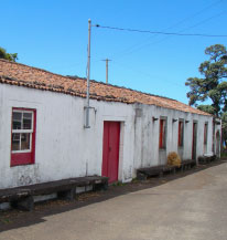
Back to the path we mentioned, you will walk among small plots of land with several different crops, limited by Banksia and cane hedges. Most of them have pasture or corn, but you can still see plants like sweet potato or vine. These lands belonged to the “Cerca”, as well as an old and long barn, to the right, entirely made of stone, with a door and three windows, that still is used as a storage space.
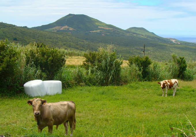
There was nothing in this headland before 1672. If it existed, it was certainly much smaller and probably made out of materials fallen from the cliff. What the fajã is today is the result of the lava flows from the historical eruption that started that year at the Cabeço do Fogo. To the other side of the island, where Varadouro is today, lava also flowed and in the same way it spread in to the sea, forming bare rock aerial platforms, leaving the village of Capelo, with its 45 houses and 160 inhabitants, temporarily isolated from the rest of the island. But human ingeniousness quickly took advantage of this adversity imposed by nature. In the fields affected by the lava they grew vine, and in the more developed soils they grew corn.
When entering a courtyard, with buildings all around it and a big gate through which you will exit, you get the feeling that you are in a private property... and in fact you are. This was the heart of the Cerca. To your right a group of adjoining buildings that were (and still are) used as a wine-cellar and hand-mill to grind the grain, with some massive stones outside serving as seats. The biggest of them was the top beam of the Lower Gate, that allowed exit of this courtyard towards the path to the harbour, from where you climbed. The other ones belonged to the first wine tank that was built here, when grapes were still pressed by the feet of the workers and that, in the meanwhile, was dismantled in the first decades of the 20th century, when a press was installed.
One of the times I went there, I was received by the couple Maria Emília and António Medeiros, owners of part of the land of the old Cerca, that were kind enough to take me on a guided tour. Inside the wine-cellar, they called my attention to the beams and to the press’s shaft, made of Brazilwood, “red and hard”, that was brought by the ancient ships and caravels, unloaded onto Horta’s docks and bought only by the “Lords that could afford it”. The mill building has two floors: bellow the grain was ground, above the steward of the estate and some of his workers slept. There is still a millstone there, acting as a table, on a cement stand inlaid with the limpet’s shells that Mr. António used to gather with a row-boat, on a reef close to the lighthouse... This was before the Capelinhos eruption. Here there is also a big cistern, separated from the houses, able to keep 109 barrels of water (more than 45.000 litres) and another one, next to the wine-cellar, that one can climb on, also serving as a viewpoint. Part of this water was used in the 2 stills that existed, making aqua-vitae another important product of this farm.
When leaving the Cerca, you come before the Chapel of Nª Sr. ª da Penha de França. History tells that in 18th century, in France, during a persecution of the Church, the Queen ordered that the statues of saints were boxed and thrown at sea, and that would justify that (supposedly... the way it is told by numerous traditions in the Azores) this image of Our Lady was driven ashore on Fajã’s beach. The local population tried to take it on their backs to Praia do Norte’s church. Strangely, the image got so heavy that the men couldn’t carry it any more. They saw this as a sign that “The Saint doesn’t want to leave Fajã”, so they turned back and built this chapel here, in 1790.
No go up the Rua da Ermida and turn left at the Rua do Porto. Up ahead turn right again in to Rua de Portugal. Passing by the last houses you will see on the headland, you start to climb over asphalt up until an apparently abandoned water reservoir, close to a group of bee hives in the land plot in front. The mark to turn left is only effective a few metres up ahead. A sign says: Praia do Norte 1,5 km. Go in that path, known as the “Ladeira dos Burros”, that will take you back to the top of the rock, this time through a less steeper way. This is an area of chestnut trees and canes, some of which may have been taken from here to be used in traditional coastal rock fishing. The path gets narrower, continues to meander through medium tension electrical poles and you will reach the top of the rock easily. Follow this access way to the agricultural plots, passing next to some of the oldest houses in Praia do Norte. When you reach a path turn left, then left again a little up ahead, crossing the riverbed of one of the tributaries of Serrado’s stream, where you will see, further uphill, the arches of the bridge built in 1886 on the main road. You will quickly find again the trail you did before. Walk it in the opposite sense and return to the starting point, thus ending this trail.

