


The only access to the sea in this Ribeirinha parish is here, where the river that gave it its name flows into the ocean, and where need demanded, in the past, that a harbour was built. Here there was also a roof-tile industry, thanks to the proximity with the clay pits where the raw material came from. The site has also a cultural interest because of the roof-tile ovens, reconstructed in 2007, that is added to its recreational and social interest. The locals meet here each year to celebrate Saint Peter in a small chapel with the initials S.P. in its façade, in a festival that, besides the religious activities, usually includes dances, sporting events for the younger and a barbecue for everyone. There is good equipment to do it. A pool, built in 2011, greatly improved the sea bathing, that before was only possible in Varadouro. Even though this is a “beach without surveillance”, it has a shower place and a camping site.
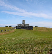
Currently there is an asphalt road to the Boca da Ribeira, but the trail that we are doing starts by going up the old dirt path that served the harbour, between the ribeirinha (stream) and the foot of the Lomba dos Espalhafatos slope. The entire slope is dressed in a forest typical of these dry soils, where the small trees Morella faya, Pittosporum undulatum and some Erica azorica prevail, along with Arundo donax, Cyrtomium falcatum and, strangely, a lot of Psidium cattleyanum in the mix. Further ahead, a simple and steep staircase to the right climbs through those woods, taking you to the top of the hill. Once there, it is impossible not to notice the Ribeirinha Lighthouse.
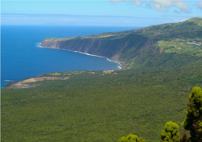
Climb a few meters on the asphalt road and go back in to the vegetation for another section of trail under the shade of the forest. You get out in a segment of the road that has now been planted with species of trees of this island’s natural flora, near the Ribeirinha Viewpoint, at an altitude of 190 metres. The landscape undoubtedly deserves a stop.
Leave the viewpoint and go down the hill, in a path like the one that brought you here, maybe even more shadowy because of the vegetation, that only here and there allows the sunlight in. At the end of that descent you will arrive once more at the valley of the river called ribeirinha, next to the Valado bridge, a spring collected in the river’s valley where the people of old used to say that “springs a water that surpasses gold, by its taste and purity”. The stone works that have been done here make it a more pleasant place.
Climb a little further, until you reach the path, turning right and going about 50 metres until you find, to the left, the new side-path. Get ready to climb the Lomba Grande. It is 430 metres until the main road. Here, to the left, you will find the continuation, with a climb of 650 metres more, until one of the paths on the top of the hill. This Caminho da Rocha Vermelha is one of the steepest and more physically demanding climbs of the trail, through paths that are sometimes wide enough for an ox cart to pass or sometimes narrower, just enough to let a man pass with his donkey.
On the secondary path where you came out, in the top of the hill, turn left and walk for about 990 metres, part on lapilli ground, part on asphalt, ignoring the ramification you will find to your right. You are in the Lomba Grande Protected Area for Habitat or Species Management. On the first sharp curb that you will find, go straight, entering the woods. Get ready to go around the hill and then descent through the old Caminho da Vila (Village’s Path). It’s an easy segment, with one or other big boulder that rolled onto the path and with the vegetation making a quite closed canopy. After you pass by some large arboreal ferns, you will finish the descent in the pastures. Besides cows, you will pass by a pig pen before reaching the asphalt road. Turn right, walk a couple of metres and go into the dirt road to your left. You will walk about 1,75 kilometres along this rural road before you reach the Charcos de Pedro Miguel Ponds.
Located in the Pedro Miguel’s graben, these depressions that you see on the ground are dry in the summer but fill up with the first rains, forming large ponds that last through the winter and spring periods. As you can see from the birdwatching station, built in 2012 by Faial’s Natural Park, this is the best spot in Faial island for birdwatching enthusiasts, that come here to register or observe the passage of migratory birds, mainly during the winter months. Anas crecca, Anas acuta and other ducks, the Plegadis falcinellus, egrets, some wader birds and other species that use the Azores archipelago to feed and rest, but also some “rarities”, stand out.
Go straight ahead, walking 1,5 kilometres more of this rural road going along the Lomba Grande. As you progress, and because the altitude also increases, some of the natural species of the Azorean laurel forest will appear along the ridges and road sides, namely Ilex perado ssp. azorica, Vaccinium cylindraceum and Woodwardia radicans, that mix with the Hydrangea macrophylla and Hedychium gardneranum. When you see a wind turbine, with its large propeller blades, up high, it is a sign that you will find to your right a shortcut that will take you once more to the top of the Lomba Grande, passing first through pastures, then through the woods.
You will reach the dirt path that goes along the top of the hill. It is 1,8 kilometres more that will take you through the Salão Wind Farm, installed in 2012, with five wind turbines VESTAS V52, of 850 kW each. This farm contributes with about 20% of the total production of electricity in the island. At the end of this path, turn left on the asphalt road and you will arrive at the Cabouco Velho Recreational Forest Reserve. This park can offer you drinking water, that you might consider providential, rest-room facilities, play park and a barbecue area for those who wish to do it. The population of Salão’s parish gathers here to celebrate Saint John. The park’s forestry patrimony is composed of a collection of diversified species of exotic trees, mixing resinous and foliaceous plants.
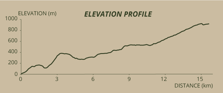
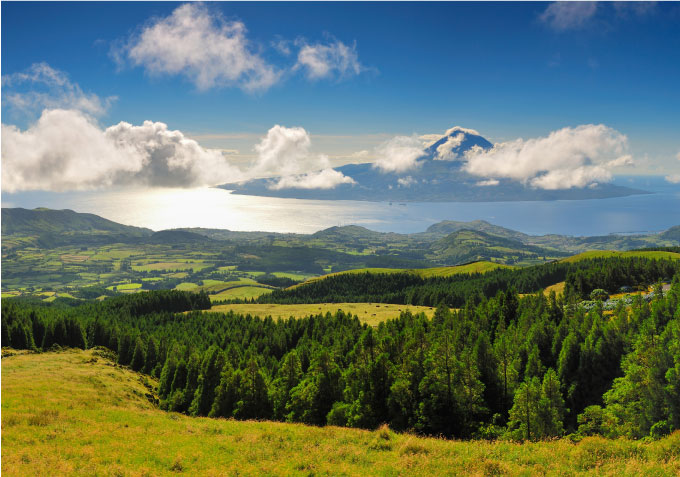
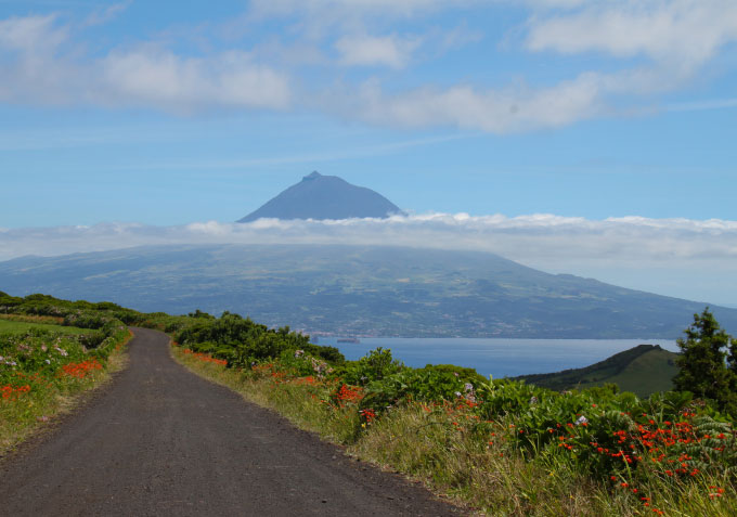
You are now at an altitude of 500 metres. Leave the Cabouco Velho park turning right, walk a couple of metres on the road and turn right again, climbing through the Caminho da Caldeira until the end of this trail, at an altitude of 900 metres. After a relatively straight beginning, the path starts a serious of curbs, winding to the top. With each curb, the landscape gets more dazzling, over a succession of hills and slopes that define geological faults. Throughout the climb you can see some curious circular tanks in the pastures. Before you finish this forest path, stop at Cabouco Viewpoint for a last look. From right to left we see the Espalamaca Fault, the Praia do Almoxarife parish’s houses, afterwards the Fault of Rocha Vermelha, followed by the Pedro Miguel parish’s houses and, lastly, the third and more evident, Lomba Grande Fault ... always with São Jorge and Pico islands framing the picture.
Resuming your walk, you come in to the Caldeira asphalt road, arriving at last at the Caldeira Viewpoint, about 200 metres from the one before, where the trail ends. From here you can go on to other footpaths.

