


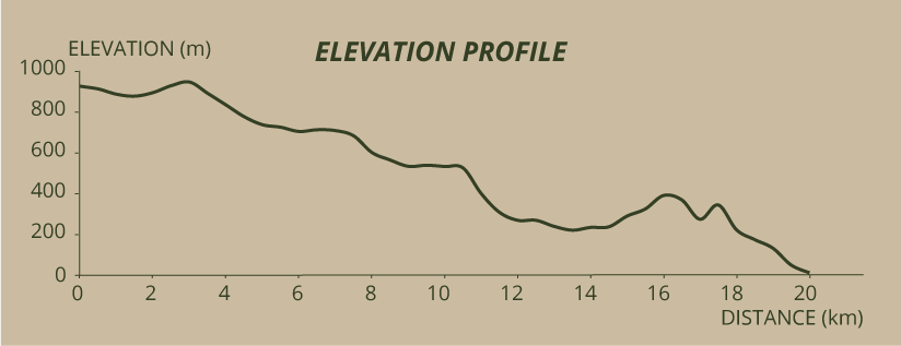
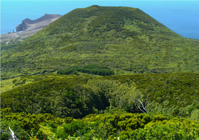
Begin by going around the crater, anticlockwise, starting the path to the right. A look to the exterior will show you the hillsides of this Caldeira that go down to the sea and the majestic Pico island in all its length. This geological structure is the result of the biggest eruption of all that helped to build Faial island. Of a trachytic nature, it formed a large volcanic structure that, in its final or post-eruptive stage, suffered collapses and landfalls in the inner walls and top edges of the crater, creating the empty space we call caldeira.
The way is clearly marked on the dirt ground by the footsteps of visitors. If it is summer, you will be able to appreciate a real aestival boom: the white from the panicles and the ears of the gramineae, of the clovers and of the Centaurium scilloides; the yellowish flowers of the Lotus, of the Parentucellia and the Lysimachia, the purple of the Prunella and of the thymes, with many other colours and species in the mix.
The outer slopes of this volcano are covered in semi-natural pastures, sometimes separated by hedges of Cryptomeria trees, Hydrangeas, or native species that use the topography to form mosaics. Actually, Caldeira is the most important biological reservoir of the island. Here we find many species of the Azorean natural flora, among which stand out tens of endemic plants. On the inner slopes, where the cows do not arrive, the hillsides show multicoloured mountain meadows, sometimes with patches of Sphagnum sp..
Occasionally the path splits in to two parallel trails, separated from each other by two or three metres. We encourage you to always take the higher route, to not to miss the beautiful views to the exterior of the Caldeira.
Some signs, made of tiles, fixed upon cement stands scattered throughout this part of the trail, offer you interesting information. The first sign shows you the location of Graciosa island so that you can admire it. The second tells you that you are still in Salão parish, though on its upper limit. The third, that you’re already in Cedros parish, to which the Caldeira area belongs to, because the longest extension of the perimeter of its rim is in the territory of this parish. At the bottom of the Caldeira you will see a little volcanic cone, from a later eruption.
Arrived half way, we have in front of us the alignment of volcanoes (cabeços) that made the island grow, the last of which is the Capelinhos volcano. A large part of what you see is ranked as Protected Landscape Area of the Central Zone. You start to see the deep grotas (ravines) dug by the erosion into the pumice stone of the outer slope. You approach the triangulation pillar of the Alto do Brejo and you start to see the lapilli path that climbs towards the Cabeço Gordo. Leave the Caldeira ridge and go down this way. Besides the landscape, you can admire the green hillsides speckled with yellow, because this color is common to most of the natural species of flowers that cover the mountains of these islands: Tolpis azorica, Leontondon sp., Hypericum sp., Lysimachia azorica and Potentilla erecta. A lot of ferns like Huperzia sp. mingle with mosses and other herbaceous plants, to form the final picture. Down below, the Cryptomeria trees follow the turns of the road.
If it wasn’t for the signals there, you might not notice that this Caminho do Brejo is going to pass over an irrigation channel (levada). It is there that you should leave it and turn left, finding the channel and following it for about 2 kilometres until you reach the reservoir to where this duct goes, in the part where it is better maintained. You will find the bridge, notable for its dimensions, but also for the view of the valley, that shows a display of trees of the Azorean endemic flora. Soon you will arrive at the tank or reservoir. Here the waters of the Levada are separated from the debris they carry, filling this big retention tank that feeds the hydroelectric plant. Once arrived here, continue your descent, through the path where the pipe that brings the water from the reservoir to the hydroelectric plant is buried. When the pipe becomes visible prepare yourself, because you will have to undertake a very slippery descent... even with the steps made from wood logs, through a forest of luxuriant trees. You get out on the stream of Cabo forest path. Turn right, walk for 150 metres then turn left in the pasture. When you reach the lapilli path, go straight for 400 metres and turn left towards Cabeço do Fogo. After you have enjoyed the view from this hill, go down until you reach the road near the “Casa das Lavadeiras”, a construction that includes a cistern, some sinks and a shed, that was ordered built by the Dabney family. Across, on the opposite side, there’s a junction with a secondary path that you should follow, making a big “L” with a turn to the right, of 800 metres plus 900 metres, until you reach Capelo park. During this section, across a wood of Morella faya, Pittosporum undulatum, Picconia azorica and pine trees, always choose the wider path.
When you reach the park, don’t miss the opportunity of visiting the “Typical Rural House”, an exceptional recreation not only of the buildings, house and annexes, but of all the objects that usually were in each room. For those with a keener interest in ethnography, there is more than enough reason to take some minutes to learn or remember. However, you can only do it from 11am to 12am or from 1pm to 2pm. Afterwards of course you can visit the deer’s enclosure or use any of the facilities that the park offers visitors. You pass by the rest-rooms, cross the park’s picnic area and you will find a path to the right that could take you back to the Levada, but you should go straight ahead, then turning left until you enter the village of Capelo. When you reach the main road, you should cross it to continue on the trail that leads to Cabeço Verde. After climbing 150 metres on the asphalt, go left through an access to agricultural fields, coming out higher above on the red lapilli path. Turn left and continue.
On one side, the Morro de Castelo Branco starts to mark the coast line, on the other, the Cabeço Verde, with its antennas, challenges us. You will find an asphalt road to reach the top of this hill, but you will climb only half of it, about 750 metres, enough to reach the beginning of the forest path that goes down to the Furna Ruim and Caldeirão. You start going down using a staircase with roughly crafted handrails, among Ilex perado ssp. azorica, Picconia azorica, Vaccinium cylindraceum, Hypericum and Woodwardia, realizing that, to your left, the Pittosporum undulatum covers something dark and deep... the Furna Ruim. A small viewpoint allows you to discover a part of this creation of nature. The size of this ravine, with steep and deep slopes is frightening. Right there, some moss belonging to the Neckera intermedia species, not frequent in the Azores islands, forms expressive curtains that cover and hang from the branches.
Continue under the incense trees for 20 metres and you will see the path splitting in two, though in reality they are the same that goes around the Caldeirão. This time go to the left, by the more shadowy part. When you reach the sunlight again, you will find a little viewpoint to your right. The crater called Caldeirão stands at your feet and the hill in front of you is the Cabeço do Canto, your next goal. In the distance, the Capelinhos volcano starts to show itself. Going around the Caldeirão, go down through a path, that is sometimes steep, until you reach the trail.
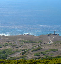
Obeying the signals, cross the path and start a new climb to conquer the Cabeço do Canto. Go up through the tall Pittosporum undulatum and Erica azorica bush, that cast shadow on some Myrsine africana that overgrow the path and to some rare Pteris incompleta: ferns that show the peculiarity of having their leaves subdivided at the base (a characteristic exclusive to this species, at least in the Azores). Prepare yourself; because the final climb of this Cabeço is steep and on slippery ground, despite the help of some wooden steps. When you reach the top go around the summit through the right, among the Erica azorica that form a path, over a hard ground where practically nothing else grows. When you reach the triangulation, pillar placed on the 346 metres altitude mark, you will have an exceptional panorama of the Capelinhos volcano and of the lighthouse that saw its rise... Don’t forget to photograph them.
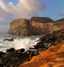
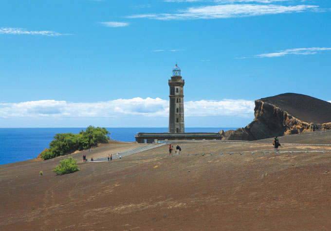
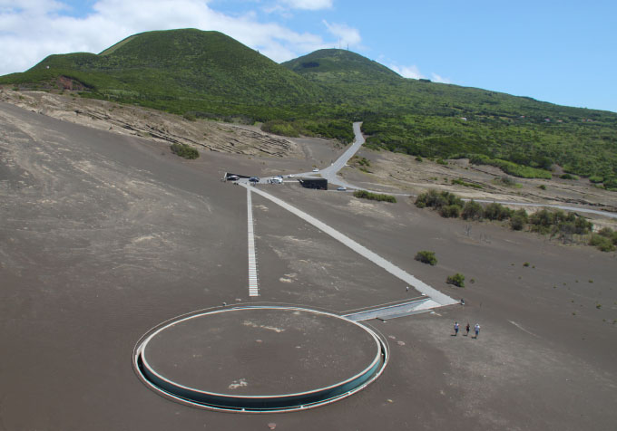
Start the descent through the western flank of the Cabeço do Canto, passing first by an area with less vegetation. Go down by a sinuous path until you reach the motocross track, easily recognizable by the relief and the barren ground, peculiar to this kind of venue. Arrived here, turn left following the vegetation until you find the path that will lead you to the road. On the way find an abandoned whale watching station. These buildings, with privileged points of view, allowed some comfort for those who looked to the sea for the presence of sperm-whales, using only a pair of binoculars and flare-rockets to give out the “Whale in sight!” sign.You reach the road, cross it and continue on the ash carpet that sometimes makes the ground unstable. You will walk until the Costado da Nau, the old coastal cliff where the island used to end, before the Capelinhos volcano made the island grow. Go down the trail, passing by the remainders of an old whale watching station, continuing until the Capelinhos Volcano Interpretation Centre, a mandatory visit, and you can also climb the old lighthouse that used to mark the land’s edge. The Capelinhos Volcano Interpretation Centre, inaugurated in August 2008, has various permanent exhibits, informative and instructive films in 2D and 3D and a rich collection of geological samples. Remember or learn how the Earth and the world’s main volcanoes were formed, until the birth of the Azores islands and specially Capelinhos, that marks the landscape in front of us.
After the visit to the Interpretation Centre, go down to the waters of Porto Comprido (the harbour that stands on Ponta Comprida) from where people would go out to sea for fishing or whale hunting, finishing your trail here.

