


This island, formed in the ocean approximately 750 000 years ago, was initially called Insula Corvi Marini, which roughly translated would mean something like “Black Cormorant Island”, and later named Corvo Island. A likely explanation for the origin of the name resides in the fact that the first sailors to reach the island might have mistaken some bird flying over the region for black cormorants (Phalacrocorax carbo), a species rarely seen here.
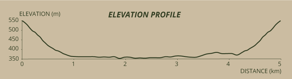
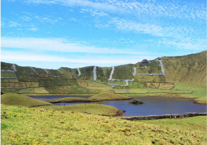
Except for the place where the village - Vila do Corvo - was established, the whole island is a circular belt of colossal cliffs. The erosive agents (wind, rain, and sea) slowly broke the rocks and wore away the not very resistant scoriae from the external flanks, advancing intensely in the western flank towards the inside of the Caldeirão. About 6 kilometres of asphalt road connect the village to the viewpoint, where the hike begins. A car will drive you up until you reach the 560 metres of altitude on the eastern region of this crater’s ridge, with a perimeter of about 6,5 kilometres. In the south region, the ridge reaches the island’s maximum altitude: 718 metres.
In case the visibility is poor, you might find it difficult to know exactly what directions to follow, despite de abundance of signs that serve as guidelines for the nature trail. However, even with a foggy road, the lowest part of the caldera might be sufficiently clear so as to justify the hike and enable a comfortable walk, characterised by the feeling that we are enclosed in a huge bowl.
The descent towards the two lagoons that are at the bottom of the Caldeirão is made along a zigzagging shortcut, sometimes a little bit damaged, muddy and slippery due to the water that runs through it, and that, even in the summer, forms small rivulets in some places. In the past, this path was more carefully maintained in order to serve the many people who took their animals to the inside of the Caldeirão and back out — not only cows, but also sheep and pigs.
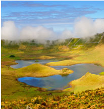
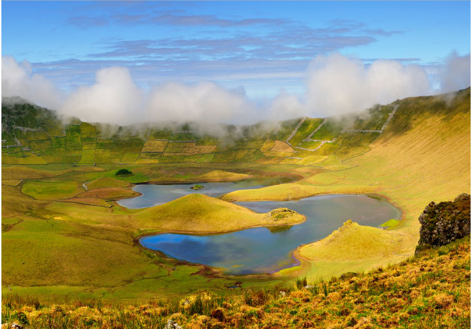
Inside the Caldeirão you will find many permanent pastures, but also important natural habitats like peat bogs, Macaronesian heaths, and lagoons. Down here, the wind’s whistle is less loud, allowing the flight of the Hipparchia azorina, a brownish black-spotted endemic butterfly that can be seen flying in the summer along with the birds. However, it is in the autumn that we witness an influx of bird watchers trying to take pictures of the migratory birds that stop here to recuperate — by resting and feeding — or even nest after the tremendously hard flights over the Atlantic Ocean. It is possible to hear and observe the Gallinago gallinago, frequently seen here, the Sterna hirundo or the Anas platyrhynchos, as well as many other rare species. Among these, and because of their historical relevance in this island, we highlight the Puffinus puffinus, which were hunted for their meat, feathers and fat, the latter being used in lamps oil lamps to light up people’s homes. Nowadays, this species from the North Atlantic whose number amounts only to approximately 200 couples, nests exclusively in the Flores and Corvo islands, their south limit on the planet. The Caldeirão was classified as Ramsar Site in 2008 and Protected Area for the Management of Habitats or Species from the Corvo Coast and Caldeirão.
At the bottom, walk around the lagoons following whatever direction you wish, for you will end up returning to the same spot in order to be able to leave the Caldeirão. It is, however, recommended that you walk anticlockwise, always with the lagoons at your left.
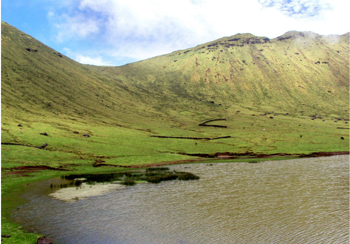
This extinct volcano, with extremely steep slopes, has two lagoons whose water originates from rainfalls or from the streams that flow down the slopes, which in turn are “fed” by Sphagnum sp. carpets that cover the higher areas. These water mirrors reflect all the colours and the topographic relief of this crater dotted with small late cones eruptions. All the features change between the summer and the winter, as the rain fills the lagoons. The stone walls, called abrigadas and mostly L-shaped, are used to protect the sheep from the wind blown from any quadrant. On the western slope, other walls geometrically divide the lands, parts of which are private properties, while the rest is uncultivated municipal land — all clear signs that these lands were always subject to considerable human activity.
Here and on the other uncultivated lands in the island, cattle’s breeding was omnipresent, even before the settlement began. The herding activity was the perfect paradigm of the communitarian life that the inhabitants of Corvo had. There was one specific day of the year — the Monday immediately after the Whit Sunday — when the island’s sheep were sheared. It was called the dia do fio (“thread day”) or dia da lã (“wool day”). During the 1960’s, there was an attempt to establish a new land exploration system in the island, to which the people strongly opposed, and which dictated the early end of sheep farming, wool production, and related traditional activities (economical and social) that were part of the identity of the island’s culture. Today, sheep are virtually inexistent. Pigs were also bred here — small caves were dug inside the Caldeirão to serve as their shelter. Even potatoes were cultivated inside the caldera. But those things no longer exist. Only a few dozen multicoloured cows that graze in the interior, occasionally breaking the silence with their moos accompanied by the birds singing.
Around the lagoons, it is not the boots of the walkers that draw the trail; it is the hooves of the cows, which often make the ground muddy and uneven. Keep walking calmly. The lagoons have fish, some about 30 centimetres long, even though they are not easily perceivable. Also at the bottom of these waters, a rare water fern — an endemic Azorean species called Isoetes azorica — creates vast and thick carpets, more than 2 metres below the surface. Equally rare is the Euphorbia stygiana, an arborescent species, also endemic, which grows in the small islet you will see in the middle of the second lagoon.
When you walk around the second lagoon, you will find a small thicket of cryptomeria, the only one in the whole caldera, as well as some marshy areas, so you must be particularly cautious and pay close attention to where you step. Continue until you find the trail you covered in order to get inside the Caldeirão and take it, covering it in the opposite direction until you reach the point where you started.

